
With the help of computer programs at the present stage, you can design a beautiful landscape. Using a variety of utilities, you will be able to form an image of your site already at the construction stage. And some tools help create 3D models.
Work to be done during design
A site planning program requires complex work to be done. The result will be a beautiful model of the future home and the area around it. However, preparatory work will be required. They include several stages:
- Collection of necessary data.
- Analysis of the received information and its processing.
- Formation of drawings with plans.
Why use programs when creating a site?
Naturally, a site planning program can significantly simplify the work. If you approach the process thoroughly, you can form several options, resulting in a project or a separate fragment of it in a three-dimensional picture. The software provides the ability to create a reliable image of the future site. A three-dimensional image will allow you to examine the image and coordinate it.

The site planning program will provide the opportunity to work out all the details. Due to this, you can get rid of uncertainty and doubt. There are a huge number of different utilities that help create landscape projects. You can even do this online. The most popular options should be considered in more detail.
Popular program for site design design
A site planning program called Sierra Home&Land Design 3D includes several different libraries. With their help, you can create landscaping projects by viewing and evaluating them in three dimensions. There are possibilities for stage-by-stage implementation of the project. Special functions have been developed for these purposes. There is also a user manual. It describes in detail the process of functioning of the program. It should also be noted that you can view your site in three dimensions as you work.
At the very beginning of work, the program for planning a summer cottage will require you to specify some parameters. These include sizes, places where buildings are located, information about what slope is typical for the relief. You will also need to indicate where you want to see paths and paths.
You can place anything on the site
As the work progresses, you can arrange all the necessary components on your site. Among them, we should highlight a fence, a recreation area, various retaining walls with stairs and ponds. It is possible to place on the diagram such structures as gazebos, bridges, trellises, pergola. But this is not all the capabilities that the software has. The user also selects plants for his site. You can immediately set all the required dimensions.

In three-dimensional mode, you can view the completed project from all sides. There are also tabs that will help you design flower beds, assessing their decorative appearance depending on the period of the year and time of day. It is possible to calculate all work performed. In addition, Sierra Home&Land Design 3D is a site planning program in Russian. All buttons and tabs are Russified. Therefore, not only a professional, but also a beginner can use it.
A program with powerful tools and extensive libraries
3D Home Landscape Designer 4.0 software is suitable not only for professional designers, but also for amateurs who would like to take care of their site themselves. It has powerful tools and extensive libraries. You can complete any task, turning all your ideas into reality. You can view the resulting project in the form of a simple diagram or in three-dimensional mode. The positive side of the software is that there is an encyclopedia of plants available. She has detailed descriptions of how to care for them.
What other advantages does the program have? The planning of suburban areas is accompanied by editing of the relief, as well as excellent visualization of all existing irregularities. It is possible to evaluate the type of generated project when taking night lighting into account.

Software Disadvantages
But the above program for planning the site of a country house also has disadvantages. They consist in high demands on computer resources. This is due to the lengthy processing of the image at the time of its output to three-dimensional mode. In addition, the detailing is not of sufficient quality. Images can only be imported and exported in software format.
Domestic development opportunities
While using a program called “Our Garden. Crystal 10.0" pay attention to the fact that it is Russian. It can be used by both professionals and amateurs. It includes a plant encyclopedia, planners, editors, resources and a photo plan. What advantages does the program have? The user will have the opportunity to see how different plants will look on the site. There are about 16 thousand of them in the encyclopedia. And there is detailed information about each.
When developing the design of the site, you can add decorative objects. With the help of planners, it will be possible to design a site of any size. In this case, the user will receive tools for developing terrain and buildings. Using the editor, you can choose paving paths, fences of any complexity, and various designs. In addition, you can create any structure yourself if you don’t like the existing templates. Land planning software can visualize the project in three dimensions.

The simplest option for amateurs
A significant advantage of the Expert Landscape Design 3D program is that it is quite simple and accessible to use. Does not have large system requests, since the size of the utility does not exceed 5 MB. Accordingly, planning a summer cottage site will not cause any difficulty. A program for dummies, easy to understand and use - that's what it's all about.
There is a large library including the names of various plants. It also includes buildings. Using the utility, you can import digital photos from other compatible software. With its help, good quality is achieved in two-dimensional form. There is also a three-dimensional mode. But its quality can be called primitive, extremely poor.

For professionals, such a software tool will be too simple. There just aren't enough graphics. However, Expert Landscape Design 3D can be used by amateurs as the first step in the process of mastering software tools that allow them to design the landscape of their summer cottage. Using the utility, only simple projects are created. However, after it you will be able to master other software much faster.
There are many options
There are a huge variety of programs for developing your own project. It is also possible to design a site and its landscape using a variety of methods. Popular tools that are suitable for both beginners and professionals have been described above. Using them, you can make a variety of your fantasies come true. Accordingly, the project will ultimately fully meet the requirements.

We hope that this review will help you decide on the optimal software tool for creating the plot of your dreams. We can only wish you good luck in this matter!
Every business owner wants to see his land holdings well-maintained, beautiful, and pleasing to the eye. He hatches ideas to implement them in any free time. Some turn to the Internet, wander through its pages for a long time in search of the most suitable landscape design option and... It is impossible to consider all the options, but here we will offer the easiest free editors for beginner designers, as well as quite complex software materials for specialist designers.
An example of a program interface for creating landscape design
Usually, before the design begins, the garden plot already contains the necessary set of elements: trees, bushes, hills. When they are boring in their natural form and do not suit the owner, then they can be easily changed and given a comfortable appearance. If this is still flat, bare land, and the owner wants to have a luxurious garden, then he will have to fork out money to purchase the necessary components, and start developing a landscape project from a blank page.
With their mastery, an inexperienced landscape designer should begin developing a design with his own hands. These editors, as a rule, are Russified and contain video materials containing lessons. 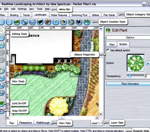
Users are invited to download for beginners, the development of which does not require special skills. However, it is not so easy to compare programs in terms of complexity and the range of functions provided online.
It is better to evaluate them taking into account your own financial capabilities and the time required to develop them. Purchasing a pirated version may result in without considering the results in the 3D version, and moreover, it does not always guarantee trouble-free use.
If the owner of the estate has a great desire to create a wonderful garden with his own hands, then he should consider and download the “Landscape Art” materials for designing projects, offered to inexperienced designers. Or buy a set of disks containing programs in this series, which are freely sold on the market in Russian.

Google SketchUp program interface for designing landscape design on a site
They will help the novice designer in developing the following elements:
- lawns, flower beds;
- reservoirs, fountains;
- paved paths;
- stone decor in the garden.
Read also
Roof color selection program
Landscape art offers two ways to frame a design: designing from scratch, from a blank page, or using a real photograph. The implementation of the latter option is convenient when there is already a house and other buildings on the site, and a garden with trees and flower beds has also been grown. This technology involves pre-loading a photograph of a site with finished buildings, and then introducing the desired landscape elements and structures there.
Computer options allow you to enter into the developed design:

An example of landscape design created in the Planner program
- paths;
- gazebos;
- fountains, small ponds;
- gates;
- fences;
- flower beds;
- lanterns
All of these design objects contain built-in libraries, or they can be created by the designer of the dacha project himself. After its completion, you can experiment with the lighting settings for day and night. It is recommended to develop two or more design versions of the site, consider them in two-dimensional images and 3D, in order to select the most successful option when comparing. Viewings can show what the garden will look like today, as well as in a few years from now. The working version of design from scratch begins with the arrangement of the terrain. Adjusting existing hills, slides, and slopes is very simple. 
To do this, the design object to be changed should be outlined to apply the appropriate transformations: raise, lower, increase, decrease.
Professional packages
They are not distributed free of charge, and, as a rule:
- expensive;
- for studying is labor intensive; difficult to use;
- have options.
However, among them there are programs that are easy to learn. It would be a good idea to read the training manual before using them. Their language is usually English or Russian, or both.
Our Garden 10_4 Crystal
Professionals call this software in Russian for creating landscapes an encyclopedia. It consists of a set of programs with a simple interface and ease of management. No prior training is required; it is readily used by landscape design masters to carry out orders from their clients and demonstrate completed projects in 3D.

An example of landscape design development in the Our Garden program
Provides the following DIY design capabilities:
- change the terrain of the site;
- place lawns, fences, paths, plants, ponds;
- see what the plot and garden will look like after a few years;
- view the final result in 3D format.
Read also
Programs for designing modern frame houses
The user does not require special computer knowledge or additional training. The editor allows you to solve the simplest problems of creating a landscape for your own summer cottages and develop complex design projects for estates and mansions with an area of up to 500 m. 
At the beginning of the design, it is necessary to use a hand-drawn site plan. Then it is filled with photographs of existing buildings, gazebos, fountains, paved paths, or ready-made decorative elements from the database are included. A garden with hedges created in the online planner looks very attractive. The final project can be easily adjusted to indicate distances to objects, and the final result can be viewed from a perspective perspective, as well as in animation and 3D mode.
Software Contents
For professional work, the program includes the following editors:
- curbs;
- fences;
- relief;
- stairs;
- paving;
- structures;
- ground cover plants;
- 3D view;
- changing photos.
In addition, there is a calculator with the help of which a working version of the estimate is developed in order to set a price for each object of the plan and show the client the geometric parameters of its calculation, such as units of length, area, etc. The creation of catalogs of price indicators, as well as their updating, is done manually. And a summary table of the cost of the entire project is calculated automatically. The name of each editor reveals its purpose. Together they cover the variety of designs used in landscape design.
Various elements for landscape design
They allow you to demonstrate created projects, show how shadows, the color of leaves, and lawns change at a specific time of day, month, or season. Even snow cover can be displayed on all design elements. The software's arsenal includes information on more than 7 thousand ornamental plants with photographs and detailed descriptions. It can be downloaded to your computer.
Trees, flowers, shrubs that will fill the designed garden are filtered during selection according to parameters such as size, soil for planting, time of flowering and replanting, life span, as well as many other characteristics.
The program includes an encyclopedia containing all kinds of plant diseases and pests. It also allows them to be identified by specific characteristics and suggests ways to prevent the harm they cause. 
There are also free tables of agrotechnical regimes for caring for flora, as well as for controlling weeds, which will definitely visit a landscaped garden. Such a rich arsenal of software functions should not scare off a novice designer, because they are not difficult to understand, especially if the user is obsessed with the idea of designing his site in the highest class.
Until recently I thought that I should make up land plan Only a cadastral engineer can.
For a long time, such a misconception was an obstacle for me to actively search for and obtain a plot of land.
Land plan or as it is also called - a diagram of a land plot, you can draw it up yourself.
In this article I will describe a step-by-step scheme for drawing up a land plot plan.
The purpose of this article: to show the value and practical applicability of: How to find free land in 40 minutes and make a diagram of a land plot? (without involving a cadastral engineer).
Why do you need a plot plan and how to draw it?
A plan or diagram of the site is required in order to submit an application to the administration for preliminary approval of the provision of a land plot. In other words, a site plan is needed to first “stake out” a plot of land and start the procedure for preparing the site for provision.
To draw up a plot plan, I needed 40 minutes of personal time and the following tools:
- Internet portal of Rosreestr,
- Agro 6 program in a free version.
The cost of drawing up a site plan was 150 rubles, plus a small commission from the payment system.
Step-by-step diagram for drawing up a land plot plan.
First: It is necessary to obtain a cadastral plan of the territory.
Second: download the trial version of Argo 6.
Third: load the cadastral plan of the territory into the program.
Fourth: in a few clicks, create a plan (scheme) of a land plot.
Fifth: insert a picture of the land plot plan into the diagram template attached to the application for preliminary approval of the provision of a land plot and print it.
Note!
Many people do not know that there are more than 53 reasons when a land plot is provided without bidding.
Not one, not two, and not even ten, but 53 bases.
Without bidding, a land plot can be obtained:
- free of charge - 9 bases;
- property for a fee - 10 bases;
- for rent - 16 bases;
- for free use - 14 bases;
- for permanent (indefinite) use - 4 bases.
Each basis has its own conditions and procedure for the provision of land.
To choose the most suitable basis, you will have to spend 10 hours intensively studying the Land Code.
However, there is an easier way.
Interactive mind map
Time is up!
Free copies are over! Access your mind map.
What does a mind map give you:
- a vision of all the reasons for obtaining land without an auction;
- clickable headings will reveal in 1 second a description of any method of obtaining a plot of land without bidding;
- In 7 minutes you will select profitable reasons for obtaining a plot of land without bidding;
There is a video instruction “How to use an interactive mind map?”
Secure free access forever, because after the timer is reset, the card will become paid.
How to obtain a cadastral plan of the territory?
The cadastral plan of the territory will serve as the basis for drawing up a plan (scheme) of the land plot.
You can get a cadastral plan of the territory without leaving your favorite sofa. It is enough to go to the Rosreestr website in the section obtaining information from the State Property Committee and submit an online request.
To submit an online request through the Internet portal of Rosreestr, I needed the number of the cadastral quarter, in the territory of which I had my eye on a free plot and a sum of money in the amount of 150 rubles.
I wrote about how to find vacant land plots in the article: for construction. Personal experience.
I received the cadastral plan of the territory the next day after submitting and paying for the request. Rosreestr sent me a notification, and I downloaded the cadastral plan of the territory.
What program should I use to read the cadastral plan of the territory and draw up a land plot plan?
The resulting files with the cadastral plan of the territory can be opened in two ways:
1st method: using the Rosreestr service called - Verification of an electronic document. The resulting file can be uploaded to this service of Rosreestr and it will open the cadastral plan of the territory in the html version, which can be viewed using Internet Explorer.
This method is not entirely convenient, because in addition to viewing the cadastral plan of the territory, I needed to draw up a plan of the land plot. And Internet Explorer is not entirely suitable for these purposes.
2nd method: using the Argo 6 program.
This program is used by cadastral engineers. Like any intellectual product, Argo 6 costs money. But the developers provide the opportunity to download a trial version of this program for free, and this version has all the tools necessary to draw up a plan (scheme) of a land plot.
I downloaded the trial version of the program from the developer’s website: http://new.argogeo.ru/
Step-by-step algorithm for drawing up a land plot plan in the Argo 6 program
1st step: open the program and click create a new drawing,

2nd step: Load the cadastral plan of the territory into the Argo 6 program and click add to drawing.

3rd step: we find on the cadastral plan of the territory the cadastral quarter on which the land plot we need is located.

In my case, the land plot has borders with other plots on three sides. The cadastral quarter in the program is highlighted with a colored line, so it is easy to navigate.
4th step: We load the topographic base so that infrastructure facilities, relief, buildings, etc. are displayed on the land plot plan.

To do this, directly from the program we select a raster background for our cadastral quarter, and it will automatically be displayed on our drawing.
5th step: A topographic map helps us see what is on a piece of land. Next, using just one program tool, we trace the contours of the area point by point.

After the contours are outlined, the program will automatically calculate the area of the land plot that you have formed and display the coordinates of all points. These coordinates will need to be indicated in the application template for preliminary approval of the provision of a land plot, which we will submit to the administration.
6th step: We draw up the final plan of the land plot and fill out an application for preliminary approval of the provision of the land plot.
To do this, highlight the selected land plot, copy the picture and paste it into the diagram template.
We fill out the table with the values of the coordinates of the points, and indicate the number of the cadastral quarter on the diagram.
As a result, the plan (scheme) of the land plot is ready.
Professionals in the field of cadastral registration will certainly say that the preparation of a land plot plan should be entrusted to professionals. And they are absolutely right.
But it is necessary to note the following: it is not a fact that the administration will provide you with the land plot you have chosen.
In the event of a legal refusal to provide a land plot, you will have to look for another land plot and again draw up a plan (scheme) of the site and, accordingly, again pay the cadastral engineer. And you need it.
It is advisable to invite a cadastral engineer when the issue of preliminary approval of the provision of a land plot has been resolved positively and it is necessary to survey the site. Until this point, it is more profitable to follow the path of least cost.
In conclusion.
In order for the process of deciding on the provision of a land plot to be launched, the prepared plan (diagram) of the land plot must be attached to the completed application for preliminary approval of the provision of the land plot and all documents must be submitted to the administration, which has 30 days to give you a written answer.
The step-by-step scheme for preparing a land plot plan, set out in this article, is based on video instructions: How to find vacant land and draw up a plot of land in 40 minutes?
Fragments of video instructions
Get video instructions from ready-made document templates,
because it's more profitable to do it yourself make plot plans rather than pay a cadastral engineer every time

If you do not have the time and energy to independently implement all the ideas for the design of your site, then professional agronomists and designers of our company "Lawn Zone" will help you with this, develop a landscape design for the site, and provide free consultations and advice.
What, where and how to place it correctly on your site?
So you finally have your own piece of land. And it doesn’t matter what its area is - 6 acres, 10 acres or 15 acres. Do not immediately rush to dig it, build it and fence it. Read specialized literature, think, consult with experienced summer residents and gardeners. Create a plan for the future site, correlating it with the cardinal points. This will help you correctly orient all your future buildings and plantings. Planning your own plot is not an easy task, and our advice will help you with this.
You will need to determine places for a house, a utility block, a recreation area, and parking a car. But keep in mind, first of all, it is necessary to solve the housing problem before the construction of the house is completed. After all, from the first days of your stay at the dacha, you will need to somehow spend the night, rest, cook food, etc. Therefore, plan to immediately build a temporary shed, which will later turn into a utility block, a warehouse for storing building materials, work equipment, etc.
Determine the sides on which the windows of the future house will face. It is advisable that these be west and east, otherwise in the rooms on the south side there may be all the time  It’s hot, but from the north it’s cold all the time. On the south side you can place a veranda or terrace; it will act as a kind of thermal insulator, preventing the house from overheating in the summer and cooling in the winter.
The house is usually located 5 m from the road along the “red line”. On the shady northern side, you can plan to plant currants and other shade-tolerant ornamental shrubs and trees. On the south side of the house, it is advisable to plant apple trees and other fruit trees - then they will receive the sunlight and warmth they need, and at the same time form shade, which will save you from the heat on hot days. Currants are planted at the western border of the site, and raspberries at the southern border.  The layout of a summer cottage implies immediately defining a recreation area and a children's playground. However, they should not be in the open sun. The recreation area is made, if possible, secluded, inaccessible to prying eyes.
If you plan to create a pond on your site, then you need to provide a place for it that is not exposed to constant sunlight. The remaining free space is allocated to the lawn, or. Behind the house, if desired, we have a vegetable garden and strawberries, and behind them we plant currants.
It is important to correctly place your plants, trees and shrubs so that their shadow does not disturb you or, especially, your neighbors. Currant and gooseberry bushes are planted at a distance of about 1.5 m from the border of the site. Apple trees, pears, plums, and cherries are planted even deeper in the garden. If the area is small, it is better to plant trees on a dwarf rootstock.
Programs for creating a DIY landscape design project
On the Internet you can find a large number of ready-made projects for summer cottages. But you can create a project yourself, based on your preferences and the location of your summer cottage. There are various landscape design programs for this purpose. Let's look at some of the simplest and most accessible of them. The presented programs are posted in Russian and they can download for free!
⊕ Self-instruction manual. Landscape design 
For those who are trying to work with programs for designing a summer cottage for the first time and want to master and use all their convenient functions, we offer a tutorial on landscape design. Interactive video instructions, voiced and commented in Russian by a professional speaker, with the opportunity to participate in the learning process, will help you quickly master all the functionality of the programs.
This video instruction covers several of the programs listed below (Garden Planner, Garden Planner, 3D Home Architect Design Suite Delux).
Download Self-instruction manual. Landscape design (124 Mb)
1. X-Designer. Garden plot planner 3D 


In this program, you can not only competently model a site using a fairly extensive library of garden plants and other landscape objects, but also see your site in all its glory at different times of the year and even at different times of the day!
After the project is formed, you can see the result from all sides and photograph the result for further reproduction of the project on the site.
Download X-Designer program (202 Mb)
2. Our garden. Ruby 9.0 


This powerful program allows you to create a landscape design project using existing digital photos. This will be appreciated by both users who create landscape design with existing objects (trees, buildings, etc.), and those who are planning a site from scratch. The program also provides a huge number of different plants, garden elements and garden objects.
Download the program Our Garden Rubin (4.3 Gb)
3. Our garden 6.0
Omega 

A powerful program from the Our Garden series allows you to create a landscape design project or design plans based on digital photographs. Integrate the plan you create with real photos. Detailed information about more than 7,700 plants contained in the program, with the ability to select soil, flowering time, place of growth, life span and much more. etc. will help you assemble and create the perfect flower garden - a flower bed of continuous flowering.
You can view the created plan in a 3-dimensional image at different times of the day or year. Depending on the specified year, the plants will be adjusted in growth form and growth. Contains a huge amount of information on caring for outdoor and indoor plants and controlling diseases and weeds. The program will be a real find for people who create a cozy corner on their site, decorated and decorated with beautiful flower beds.
Download the program Our Garden Omega (690 Mb)
4. 


One of the simplest programs that allows you to create a garden layout by dragging all the necessary and desired elements onto the plan and arranging them as you wish. Also, for convenience and clarity, you can change the foliage color and scale.
Download Garden Planner 3 (3.5 Mb)
5. 3D Home Architect Design Suite Deluxe 


This interesting program allows you to create a design project for a summer cottage or other interior from scratch. A rich selection of design elements (plants, lighting, fences, trellises and even playgrounds) with the ability to adjust their sizes will help you create an easy and effective site design in 2D format, and with the help of the built-in functionality you can view it in 3D (in all perspectives, angles and at different distances).
Download the program 3D Home Architect Design Suite Delux (222 Mb)
For professionals who are familiar with design programs first-hand, we can recommend using the following programs:
1. AutoCAD 


The most famous and universal program for creating design. Professional program for designers. Makes it possible to build relief according to coordinates,  contours, surface breaks, etc., create contours, visualize objects and reliefs. Using AutoCAD, various design documentation is drawn up, which is usually used in professional activities.
2. 3D Max
A complex program that provides great opportunities for designing, placing and creating objects in 3D format. It is also used mainly by architects and engineers, because there are specialized courses for mastering this program.
3. Punch! Professional Home Design 


A professional program, but more accessible to the average person. A program for creating a three-dimensional plan of a plot, house, and apartment. Lots of standard objects that can be edited. Huge opportunities for creating high-quality professional projects, as well as design documentation. Ability to add digital photographs, hand-drawn (scanned) drawings and plans. Image visualization.
Download Punch! Professional Home Design (2.2 Gb)
Download the crack program Punch! Professional Home Design (16.2 Mb)


")


