
Algeria is located in northern Africa. One of the largest countries on the continent. The total area of the country is 2,381,740 km2. The length of the coastline is 998 km.
One of the largest and most developed countries in Africa, located in the north of the continent. The country's territory occupies the central part of the Atlas mountain system and the north of the Sahara Desert. The relief of northern Algeria is represented by two main ridges - the Coastal (or Tel Atlas) and the Saharan Atlas and intermontane plains. The highest point is Mount Takhat (3003 m) in the Ahaggar highlands. The territory of the Sahara is occupied by rocky deserts - hamads and sandy ones - ergs. The river network is poorly developed (the main river is Shelif), most of the rivers regularly dry up. It borders with Morocco in the west, with Tunisia and Libya in the east, with Niger, Mali, Mauritania in the south. From the north it is washed by the waters of the Mediterranean Sea. Algeria belongs to the countries of the Maghreb ("Arab West"). The total area of Algeria is 2381.7 thousand square meters. km.
Nature of Algeria
The Tell Atlas mountain range running in the north along the coast is cut through by a few bays and plains. The lowlands around the cities of Algiers and Oran are densely populated. Small bays are used for fishing, export of iron ore and oil. Tell Atlas rises more than 1830 m above sea level and includes the Tlemcen, Greater and Lesser Kabylia and Mejerda massifs.
At mid-altitudes there are Mediterranean-type shrubs and cork oak forests. At higher elevations, cedar and pine forests once grew, but as a result of deforestation, fires and livestock grazing, many mountainous areas have turned into shrub-covered wasteland. The climate is Mediterranean, with hot, dry summers and warm, rainy winters. In winter, snow covers only the highest peaks. The range of average annual precipitation amounts is from 760 mm on the coast to 1270 mm on the seaward slopes of Tell Atlas and less than 640 mm on its internal slopes.
The southern part of Tell Atlas is a high plateau with an average height of 1070 m. This area is characterized by semi-arid climatic conditions with annual precipitation of 250–510 mm. In more humid areas, cereals and alpha grass (esparto) are cultivated, the fibers of which are used to make ropes, fabrics and high-quality paper. Salt lakes (called chotts) and salt marshes occur at lower elevations with a dry climate. Located even further to the south, the Saharan Atlas rises to a height of 150 m above the plateau level and then descends towards the Sahara by more than 300 m. The most elevated part of the Saharan Atlas is the Ksur, Amur and Ouled-Nail mountain systems. The annual rainfall on the northern slopes is approx. 510 mm, in the south - 200 mm. Thanks to its abundant grass cover, the Saharan Atlas serves as a convenient grazing area for livestock.
Statistical indicators of Algeria
(as of 2012)
The rest of the country is occupied by the Sahara Desert. The average altitude in the Sahara is approx. 460 m. In the area of the Ahaggar (Hoggar) massif near the southern border of Algeria there is the highest peak of the country, Mount Takhat - 2908 m. Most of the Sahara is occupied by gravelly and pebble deserts (hamads and regis), and approximately 1/4 of the part is sandy deserts (ergs) . The day is hot, sometimes the temperature reaches 35°, but the nights are cool. Precipitation is extremely rare. In oases, under conditions of constant irrigation, the date palm grows. In Algeria, only a few rivers have a constant flow; the rest are fed by precipitation. Sources of water supply are wells dug in dry river beds (wadis), in many places underground water is used, coming to the surface through artesian wells and foggara - horizontal tunnels dug at a slight slope.
Geological structure of Algeria
In the territory of Algeria, there are regions of different geological structure and metallogeny - the Sahara (part of the ancient African platform) and the Atlas (sector of the Mediterranean geosynclinal belt), separated by the South Atlas fault. In the south of the Sahara region, the Ahaggar (Hoggar) shield stands out, in the southwest - El-Eghlab (Regibat). They are composed of Archean crystalline rocks, metamorphosed volcanic-clastic and carbonate deposits of the Lower Proterozoic and Riphean-Vendian; In Ahaggar, geosynclinal-orogenic volcanic-sedimentary deposits and Taurirt granites (650-500 million years) are also widely developed. The platform cover is formed by marine terrigenous-carbonate sediments of the Riphean-Vendian (especially in the Regibat massif), lagoonal-continental and marine sediments of the Paleozoic (thickness 1.2-3.8 km), sandstones and evaporites of the Triassic, clays and sandstones of the Jurassic - Neogene.
In the cover of the Sahara Plate there are syneclises (Tindouf, Western and Eastern Sahara), separated by uplifts, and the Ugarta zone, which is an aulacogen, the folding of which appeared at the end of the Carboniferous. Riphean-Vendian volcanics and granites are associated with deposits of uranium, tin, tungsten, rare metals and gold ores in Ahaggar. In the Tindouf syneclise, among the Paleozoic clay-sand deposits of the platform cover, the largest iron ore deposits are localized, and in the south of Ahaggar there are promising uranium deposits. Anticlines in the sediments of the cover on the northern plunging of Ahaggar contain unique deposits of oil (Hassi-Mesaoud) and gas (Hassi-Rmel).
In the folded Atlas region, evaporites, gypsum-salt-bearing clays and red clastic rocks of the Triassic are developed, overlain by marine terrigenous-carbonate sediments and carbonate-terrigenous flysch (Jurassic, Cretaceous, Paleogene). In the north, the Neogene is represented by marine volcanic-sedimentary, clayey-carbonate sediments, in the south - by continental sediments.
In Tel Atlas, folded rocks of the Mesozoic-Cenozoic (up to and including the Middle Miocene) form a series of tectonic nappes (nappes) moving from north to south. In the coastal zone, andesites and granitoids of the Neogene are insignificantly developed, in the massifs of Greater and Lesser Kabylia - Precambrian metamorphic rocks and Paleozoic shales, which protrude to the surface. To the south of Tel Atlas there is a platform block of the High Plateaus (Oran Meseta), where the folded Hercynian basement is covered by a thin, slightly deformed Mesozoic-Cenozoic cover. In the handfuls, terrigenous and volcanic-shale rocks of the Paleozoic are exposed, crushed and intruded by Hercynian granitoids. South of the High Plateaus there is a moderately folded zone of the Saharan Atlas, formed at the site of the Mesozoic trough. In general, the Atlas region is dominated by near-latitudinal folds and faults of eastern and northeastern (or “Atlas”) strike, as well as submeridional “Red Sea” faults superimposed in the northern part of Algeria on the Tel Atlas overhangs. Longitudinal and transverse faults determine the placement of volcanics, evaporite diapirs and the most important ore-bearing zones with deposits of ferrous and non-ferrous metals in the Atlas region. In Northern Algeria, deposits of iron, zinc, lead, copper, antimony, mercury and various types of non-metallic raw materials are associated with Mesozoic-Cenozoic rocks.
The territory of Algeria is characterized by high seismicity, which is associated with movement along faults and ridges in various zones of Northern Algeria. The most seismic is Tel Atlas (6-7 points), within its boundaries there are coastal zones (Tenes-Chershel, Oran-Mostaganem and Shelif).
Minerals of Algeria
In Algeria, deposits of oil, natural gas, coal, uranium ores, iron, manganese, copper, lead, zinc, mercury, antimony, gold, tin, tungsten, as well as phosphorites, barite, etc. have been discovered and explored.
Algeria ranks third in Africa in terms of oil reserves. On the territory of Algeria, 183 oil and gas fields are known, confined to the Algerian-Libyan oil and gas basin; Most of the deposits are located in the northeast of the Sahara region. The largest oil field, Hassi Mesaoud, is localized in Cambrian-Ordovician sandstones. The fields of Zarzaitin, Hassi-Tuile, Hassi-el-Agreb, Tin-Foue, Gourd-el-Bagel, etc. have significant reserves. Algeria ranks first in Africa in terms of gas reserves. The largest gas field, Hassi-Rmel, lies in Triassic sandstones; significant gas reserves have been explored in the Gurd-Hyc, Nezla, Oued-Numer and other fields.
Coal reserves are insignificant; its deposits (Kenadza, Abadla, Mezarif) are concentrated in the Upper Carboniferous sediments in the Beshar basin. The coals are fatty, caking, medium ash (8-20%), contain 20-35% volatile impurities and 2-3.5% sulfur.
Algeria ranks 4th in Africa in terms of uranium ore reserves. Hydrothermal vein deposits of uranium ores Timgauin, Tinef and Abankor have been explored in Ahaggar (proven reserves 12 thousand tons, U3O8 content 20%); in the south of the shield, uranium occurrences are known in Paleozoic sandstones (Tahaggart).
Algeria ranks second in Africa in terms of iron ore reserves. In Northern Algeria, metasomatic iron ore deposits have been explored in Aptian reef limestones (Jebel Ouenza, Bou Khadra), the total reserves of which are over 100 million tons, the Fe content is 40-56%. In the Tindouf syneclise, the largest Devonian sedimentary deposits of oolitic iron ores in Algeria were discovered - Gara-Dzhebilet (total reserves 2 billion tons, Fe content 50-57%) and Mesheri-Abdelaziz (2 billion tons, 50-55%). The reserves of manganese ores are insignificant; they are confined to the volcanic-hydrothermal deposit of Oued Guettara (total reserves 1.5 million tons, Fe content 40-50%) in the Bechar region.
Algeria ranks second in Africa in terms of lead and zinc ore reserves. In Northern Algeria, stratiform, vein (telethermal) and lens-shaped vein (hydrothermal) deposits of polymetallic ores are developed. Stratiform deposits of lead and zinc ores are located in carbonate deposits of the Jurassic (El-Abed, Deglen), Cretaceous (Kerzet-Yousef, Meslulla, Jebel Ishmul), veins in sandy-clayey rocks of the Cretaceous (Gerruma, Sakamody) are associated with diapirs of Triassic evaporites. Volcanogenic and plutonogenic-hydrothermal copper-polymetallic deposits in Cretaceous-Neogene rocks are associated with Miocene volcanics (Bu Sufa, Oued el-Kebir) and granitoids (Bu Douka, Ashaysh, Ain Barbar, Kef um Tebul). Ore occurrences of cuprous sandstones are known in Cretaceous and Triassic deposits (Ain Sefra, in the western Saharan Atlas), Cambrian (Ben Tajik in Ugarta) and Vendian (Khanq in the south of Regibat).
Algeria ranks 1st in Africa in terms of mercury reserves (about 4% of global reserves). Deposits of mercury ores were identified in the Azzab region among the terrigenous-clastic rocks of the Cretaceous - Paleogene and in Precambrian shales (Genish deposits - total reserves in terms of metal 4.5 thousand tons, Hg content 1.16%; Mpa-Cma, respectively, 7.7 thousand t, 3.9%; Ismail - worked out). Algeria ranks second in Africa in terms of antimony ore reserves; they are concentrated in Northern Algeria at the Khammam-Nbails telethermal field. Algeria ranks first in Africa in terms of tungsten ore reserves. In Ahaggar, quartz-cassiterite-wolframite-greisen-vein bodies Nahda (Launi), Tin-Amzi, El-Kapycca, Bashir, Tiftazunin and others, associated with Taurirt granites, have been explored. In Northern Algeria, the Belelieta skarn-scheelite deposit is known.
The most significant hydrothermal vein gold deposits - Tiririn, Tirek, Amesmessa, Tin-Felki, etc. - were explored in the Precambrian crystalline rocks of Ahaggar; exploration and search for gold continues.
The Bou-Douau deposit has been discovered in Northern Algeria.
Algeria ranks 5th in Africa in terms of phosphorite reserves. In Northern Algeria, deposits of granular phosphorites are confined to clay-carbonate deposits of the Upper Cretaceous - Paleogene. The largest deposits are Dzhebelyonk, El-Quif, Mzaita (see Arabian-African phosphorite province).
Algeria ranks second in Africa in terms of barite reserves. In Northern Algeria, the Mizab vein deposits (total reserves 2.15 million tons, BaSO4 content 90%), Affensou, Bou Mani, Varsenis and Sidi Kamber have been identified, in the Bechar region - the Bou Kais, Abadla and other vein fields. other minerals in Algeria, a large deposit of celestine Beni-Mansour (Northern Algeria) has been explored, the total reserves of which are 6.1 million tons; known deposits of pyrites (reserves are small), table salt, etc.
History of the development of mineral resources. The oldest evidence of the use of stone for making tools was found in Ternifin and dates back to the Lower Paleolithic (about 700 thousand years ago). From the Neolithic era, the extraction of clays for the manufacture of ceramic utensils began (5-4th millennium BC), from the 2nd millennium BC. - stone for the construction of large funeral structures - dolmens. Information about the developed mining and metallurgical production in the Middle Ages is given in the works of Arab scientists and travelers al-Yakubi (9th century), al-Bakri (11th century), al-Qazwini (13th century), etc. The main mining centers were concentrated in the north - iron ore mines "Nemours" and "Beni-Saf" near the city of Arzev (Western Algeria), as well as near the cities. Setif, Annaba, Bejaia; copper mines in the Jebel Ketama mountains. In the department of Constantine (near Majana, Eastern Algeria), the development of deposits of silver, lead ores, and building stone (no later than the 16th century) is also mentioned. Mercury ore was mined near the city of Arzev. In the 10th century, salt mines were located on the Jebel el-Melkh hill ("Mountain of Salt").
After the colonization of Algeria (1830), intensive searches for minerals began in the country. Industrial exploitation of iron ore deposits (Ain Mokra, Beni Saf, Jebel Ouenza, Mokti el-Hadid) has been carried out since the 50-60s. 19th century, at the same time intensive development of deposits of lead, zinc and copper ores (Muzaya, Oued Merja, Tizi Ntaga), and phosphorites (since 1893) was carried out. In 1907, the main coal deposit of Algeria, Kenadza, was discovered, the maximum production of which was carried out during the Second World War 1939-45.
Mining. General characteristics. The leading branch of the mining industry is oil and gas production (more than 90% of the value of all products of the mining industry); provides the majority of foreign exchange earnings. In 1981, oil and gas accounted for 96% of the value of the country's exports, which amounted to 62 billion Algerian dinars. In the mining industry, the public sector plays a leading role. In the oil and gas industry, a monopoly position is occupied by the state company "Société Nationale pour la Recherche, la Production, le Transport, la Transformation et la Commercialization des Hydrocarbures" ("SONATRACH"). The company has taken control of oil and gas reserves and production, all main oil and gas pipelines, gas liquefaction and oil refining plants.
The total number of personnel employed in the oil and gas industry is about 36 thousand people (1980). The Algerian government is promoting the development of the oil and gas industry by merging with foreign capital (up to 49%) while retaining 51% of the shares with SONATRACH. The company carries out production, as well as exploration for oil and gas, in the Sahara together with the French companies "Total", "Compagnie Française de Pétrole", "Compagnie de Recherches et d'Activities Pétrolières", US companies (Getty Oil Co.), Spain ("Hispanoil"), Germany ("Deminex"), Poland ("Copex") and Brazil ("Petrobras"). After the nationalization of mines and quarries (1966) in the Algerian mining industry, the state company "SONAREM" completely controls the exploration, production, consumption and export of all solid minerals (total number of employees about 14 thousand people, 1980). The company includes 30 mines and quarries and conducts exploration in Northern Algeria and the Sahara. Algeria is one of the leading producers of mercury. The extraction of iron ores and non-ferrous metals is insignificant.
Climate of Algeria
The climate of Algeria is subtropical Mediterranean in the north and tropical desert in the Sahara. Winter on the coast is warm and rainy (12° C in January), in the mountains it is cool (there is snow for 2-3 weeks), in the Sahara it depends on the time of day (at night below 0° C, during the day 20° C). Summer in Algeria is hot and dry. Annual precipitation ranges from 0-50 mm in the Sahara to 400-1200 mm in the Atlas Mountains.
Water resources of Algeria
All Algerian rivers are temporary watercourses (oueds) that fill during the rainy season. The rivers of the far north of the country flow into the Mediterranean Sea, the rest are lost in the sands of the Sahara. They are used for irrigation and water supply, for which reservoirs and hydroelectric power stations are built on them. The largest river is Sheliff (700 km). Lake basins (sebkhas) also fill up during the rainy season, and in the summer they dry out and become covered with a salt crust up to 60 cm thick. In the Sahara, in areas with large reserves of groundwater, the largest oases are located.
Flora and fauna of Algeria
Algeria has a poor flora. In some places in the mountains there are cork oak forests, semi-desert and desert vegetation. In the north of the country, oak, olive, pine and thuja grow. The Sahara Desert contains virtually no vegetation, and there are very few oases. The most typical animal species for the country are jackals, hyenas, antelopes, gazelles, and hares are also found.
Population of Algeria
At the time of the French conquest, the population of Algeria was approx. 3 million people. In 1966 it already reached 11.823 million people, and in 1997 – 29.476 million people. In 1996, the birth rate was 28.5 per 1,000 people and the death rate was 5.9 per 1,000 people. Infant mortality (children under one year old) is 48.7 per 1000 newborns. In the mid-1990s, approx. 68% of the population was under 29 years of age.
Algeria was originally inhabited by peoples speaking Berber languages. These peoples back in 2000 BC. moved here from the Middle East. The majority of the modern population uses a colloquial version of Arabic in everyday life. Arabs settled in Algeria during the Islamic conquests of the 7th and 8th centuries. and nomadic migrations of the 11th–12th centuries. The mixing of two waves of settlers with the autochthonous population led to the emergence of the so-called Arab-Berber ethnic group, in the cultural development of which the Arab element played a dominant role.
As the main ethnic subgroup of Algerian society, the Berbers play an important role in the life of the country. During the Roman and Arab conquests of North Africa, many Berbers moved from the coast to the highlands. Berbers make up approximately 1/5 of the country's population. The largest concentration of the Berber population is found in the mountainous area of Djurjura, east of the capital, known as Kabylia. The local residents, the Kabyles, have settled in many cities of the country, but carefully preserve ancient traditions. Other significant groups of the Berber population are represented by the Shawiya tribal alliances, originating from the mountainous region around Batna, the Mzabita, settled in the oases of Northern Sahara, and the Tuareg nomads living in the far south in the Ahaggar region.
After the conquest of Algeria by France in the 19th century. The size of the European part of the population increased, and by 1960 approx. 1 million Europeans. Most had French roots, the ancestors of the rest moved to Algeria from Spain, Italy and Malta. After Algeria declared independence in 1962, most Europeans left the country.
Most of the Algerian population are Sunni Muslims (Malikis and Hanafis). A number of followers of the Ibadite sect live in the Mzab Valley, Ouargla and Algiers. The state religion of the country is Islam. There are approx. 150 thousand Christians, mostly Catholics, and approximately 1 thousand adherents of Judaism. The official language is Arabic, but French is still widely spoken. Some Berber tribes speaking Tamahak and Tamazirt acquired their own written language. Several books have already been published in the Tamazirt dialect in Algeria.
About 3/4 of the population is concentrated in the foothills of the Tell Atlas, approximately 1.5 million people live in the highlands and less than one million in the Sahara Desert. The highest density is observed near the capital and in the Kabylia region.
In the east it borders with Tunisia, in the south with, and in the west with Western Sahara, Morocco and Mauritania. The northern border of Algeria is the coast.
The territory of Algeria includes the central part of the Atlas Mountains and the northern part of the Sahara Desert. Two main ranges - the Saharan Atlas and the Coast Range, as well as the intermountain plains represent the picturesque topography of northern Algeria. The territory of the Sahara is occupied by the rocky hamada deserts and sandy ergams. The main river in Algeria is the Shelif, but the river network in Algeria is poorly developed; most rivers dry up during the hot months of the year.
Despite this, there are a lot of beautiful places in Algeria.
The vegetation of the Algerian coast is represented by evergreen hard-leaved trees and shrubs. The mountains in Algeria are covered with forests of holm oak, thuja, juniper, Atlas cedar, Aleppo pine and cork oak.
The fauna of this country is quite poor, as it was significantly exterminated by humans, especially in the 19th and 20th centuries. Macaques, hares and wild boars survive in the Atlas forests. While the Sahara is home to jackals, cheetahs, gazelles, hyenas, birds of prey, genets, phalanges, addax antelopes, lizards, fennec foxes, turtles, snakes, small rodents, locusts and scorpions.
Algeria (Algeria) - a state in North Africa, official name - . In Arabic it sounds like al-Jezair, which means “ islands". Most of the country's territory is occupied by the Sahara Desert. In the north, Algeria is washed by the Mediterranean Sea, in the east it borders with Tunisia and Libya, in the south with Mali and Niger, in the west with Mauritania, Western Sahara and Morocco. Algeria is the second largest African state.
Algerian People's Democratic Republic
1. Capital
Capital of Algeria- is Algeria City, yes, it’s not a typo, the name of the capital coincides with the name of the country. Algeria- the main financial and industrial center of the state. The city has been given the status of the main port of the Algerian Democratic People's Republic, where ships of the Mediterranean region refuel. 
Algiers city also known as " Staircase city“, because there are a lot of stone stairs here, smoothly turning into streets. This layout resulted from the unusual topography of the city. These stairs connect two parts of the city: Lower city– these are new areas consisting of wide streets and boulevards, which are located near the sea, with Upper town, which represents the historical center of the capital, with endless narrow streets and one-story houses.
2. Flag

On Algerian flag pictured:
Two vertical stripes of the same width: green on the left, white on the right. Red crescent and red five-pointed star in the center flag.
The meaning and a little history of the Algerian flag:
The green stripe on the flag, the crescent with a star symbolizes Islam, and the white stripe symbolizes purity. The crescent and star are also signs of Islam. The crescent moon has slightly longer horns than other Muslim countries. This is based on the Algerian belief that the long horns of the crescent moon bring good luck.

Official coat of arms of Algeria, which appears before us today, was officially recognized in 1976. The inscription bordering the emblem of الجمهورية الجزائرية الديمقراطية الشعبية in Arabic reads People's Democratic Republic of Algeria. At the bottom, a crescent and a star are visible, which are the traditional symbol of Muslim countries; the red color of these symbols reflects freedom Algerian people. On the left and right sides of the coat of arms are the main symbols of the rural industry - ears of corn and an olive branch. The buildings depicted in the very center of the coat of arms are a symbol of the industrial sector of the state.
Mountain represented on coats of arms These are the Atlas Mountains. At the top you can see the rising sun, which symbolizes the changes and development of the country, under which a palm is depicted. It serves as a talisman in Arab countries. This is the palm of Fatima, Muhammad's daughter from his first wife.
4. Anthem
listen to the Algerian anthem
watch and listen to the Algerian anthem
5. Currency
Algerian dinar– is official Algerian currency, consisting of 100 centimes, the letter code of the Algerian dinar is DZD, and the abbreviation is also often used D.A.. Currently in circulation are coins in denominations of ¼, ½, 2, 5, 10, 20, 50 and 100 dinars, as well as banknotes in denominations of 100, 200, 500 and 1000 dinars.
Well Algerian dinarto the ruble or any other currency can be viewed on the currency converter:
Algerian dinar looks like this:
Coins of Algeria

Algerian banknotes

6. 10 Largest cities in Algeria:
- Algiers (capital)
- Constantine
- Djelfa
- Batna
- Setif
- Annaba
- Blida
- Sidi Bel Abbes
- El Khrub
7. Geography
Area of Algeria: 2,381,740 km 2
Algerian People's Democratic Republic- a state in North Africa. In the north it is washed by the Mediterranean Sea, in the east it borders with Tunisia and Libya, in the south with Niger, Mali and Mauritania, and in the west with Morocco.

Algeria is divided into 4 main regions. In the north, stretching along the coast and going south is the first region - Tel, which mainly consists of narrow valleys ending in part of the Atlas mountain system. The main river of the country, Chelif, flows into the Mediterranean Sea, originates in the Atlas Mountains. Further to the south lies the second region - the High Plateau, which consists of depressions that during the rainy season form small lakes, drying up, they turn into salty areas - chott or chott. The third region is the Saharan part of the Atlas Mountains. The fourth region is the largest in area, occupying more than 90% of the country's territory - Algerian Sahara. Most of the Sahara is occupied by gravelly and pebble deserts (hamads and regis), and approximately 1/4 of the part is sandy deserts (ergs). In the south of the region are the Ahaggar Mountains and the highest point Algeria Mount Takhat (3003 m).
In Algeria There are only a few rivers that have a constant flow; the rest are fed by precipitation. Sources of water supply are wells dug in dry river beds; in many places, underground water is used, which reaches the surface through artesian wells and foggaras - horizontal tunnels dug at a slight slope.
Algeria on the map:

8. How to get to Algeria?
9. Things to see
Sights of Algeria. Algeria is a country with a huge amount mysterious places, thanks to which the flow of tourists from all over the world increases every year, despite political conflicts.

Interesting places and attractions of Algeria are represented by unique natural resources: the Tassilin-Ajer plateau, green oases with rare animals, thousand-year-old cypress trees and much more that will amaze you with its splendor. History buffs should definitely visit the ruins of the ancient capital, the city of Hammadid, and admire the unique architecture here.
Here's a small one list of attractions, which you should pay attention to when planning excursions around Algeria:
- Algiers Observatory
- Architectural and historical complex – Timgad
- Atlas Mountains
- Ahaggar
- Tomb of the North African conqueror Okba
- Gurey
- Mzab Valley
- Ancient city of Qala Beni Hammad
- Royal Mausoleum of Mauritania
- Jami al-Jadeed Mosque
- Shrea National Park
- Teniet El Had National Park
- Belezma National Park
- National Museum of Fine Arts
- Djurjura National Park
- Tassilin-Ajjer Plateau
- Ruins of Kbor er Rumia
- Old town Kasbah
- Walls of the old city in Constantine
- Cathedral of Our Lady of Africa
- Tipasa
- Tassil-Adjer
- Tlemcen
- Fort Santa Cruz
10. What’s the weather like here?
Climate of Algeria. In Algeria 3 climatic zones can be distinguished:
- coastal - Mediterranean humid climate with pressure differences, average January temperature 7 - 10 ° C, July 35-40 ° C;
- medium - significant temperature changes: in summer up to 35 ° C, in winter up to -5 ° C;
- the southern one, which includes the Sahara Desert, - dry winds often lead to sandstorms.
In Northern Algeria The climate is subtropical, Mediterranean with warm, rainy winters and hot, dry summers. The average January temperature on the coast is 12 ° C, on the intermountain plains - 5 ° C, and in July 25 ° C. Summer heat is difficult to tolerate due to dry winds. There are often severe droughts. A significant portion of precipitation falls in November–January. In winter, in mountainous areas, snow remains on the peaks for up to 10-20 days or more.
In the transition zone to Algerian Sahara the climate is drier, the average July temperature rises above 30 °C, precipitation - 200-400 mm per year. The Sahara has a desert climate, very dry with only 50 mm of precipitation per year, and sometimes there is no rain at all. Summer daytime temperatures are 40 ° C and above, at night - 20 ° C, and in winter during the day - about 20 ° C, at night it drops to 0 ° and below.
The most suitable for relaxation will be the shores of the Mediterranean Sea. This is where the sunniest weather is and there are comfortable and beautiful beaches. Winters in this place are warm and rainy, the air temperature is about 12 degrees even in January.
11. Population
Population of Algeria amounts to 40 822 449 million people (as of February 2017). Ethnic composition population: Algerian Arabs - 83%, Berbers - 16%, Europeans - less than 1%. Both Arabic and French are taught in schools, but learning official language - Arabic- is mandatory. Average duration life in Algeria about 70 years old. The main causes of diseases are associated with poor cleaning and dirty water, as a result the population suffers from hepatitis, measles, cholera, gastrointestinal infections, and typhoid fever.
What should you wear?

What kind clothes you need to take with you when going to Algeria? Clothes for walking should be chosen with extreme caution, open and bright outfits should be taken into account, make sure that there are no copies of coins on clothes - this wardrobe item in Algeria unacceptable. For them it is an insult and sacrilege.
Women should temporarily put aside their revealing outfits, short skirts, tight-fitting clothes and blouses with a deep neckline. Try not to stay in the open sun for a long time, as the temperature is quite high and it is very easy to get sunstroke, so do not be outside without a hat.
12. What about something to eat?

National cuisine of Algeria is quite diverse, and it was formed under the influence of its closest neighbors, having absorbed the best culinary traditions of Arab, French, Turkish, Moroccan and Tunisian cuisines. The main national dish is Cous Cous. The main component of this dish is semolina. The cereal is soaked in olive oil, then small lumps are made from it, various spices are added and steamed. Served as a finished dish or as a side dish for fish, meat and vegetables. You can also add nuts, dried fruits, raisins to Cous Cous and “voila” you get a sweet dessert called Mas Fus.
In addition to Cous Cous and McFus, be sure to try:
“Meshui” is a very juicy young veal steak cooked on the grill. "Harissa" is a spicy tomato sauce with the addition of pepper, coriander, garlic, cumin, lemon juice and mint. “Puree soup with lamb peas” (chickpeas) “Shakshuka” - salad of fresh vegetables and boiled eggs. “Tajin” is essentially our omelette, but with the addition of potatoes and chicken. "El Ham Lalu" - a lamb dish with vegetables and fruits. "Rashta" - tender egg noodles.
13. Note to shopaholics

Shopping in Algeria. Algeria is not particularly famous in the world for its shopping opportunities, but you can find souvenirs to suit every taste. There are tons of lovely Algerian shops here that sell amazing and unique goods - jewelry, clothing, cosmetics and perfumes.
« Stone flowers"are one of the most popular souvenirs brought by tourists from Algeria. The Dead Sea is covered with salt during the rainy seasons, and it is here that such “miracle roses of the desert” are formed from sand and salt crystals. You can also purchase in Algeria bronze and copper products, handmade leather goods, national clothing, silver jewelry. Berber rugs and carpets and original wickerwork are popular among tourists.
14. Rules of exemplary behavior
Peculiarities of behavior in Algeria. Do not wear revealing or provocative clothing. For safety reasons, it is not recommended to move independently on the border with neighboring countries. Remember that you should not photograph the local population, especially women. If you're lucky, an Algerian man, at best, will simply look disapprovingly or turn away, but let's not talk about the worst. But a woman can call for help and they will definitely stand up for her, not in a very affectionate manner. For them, such behavior is very offensive, and they can easily take or break the camera.
15. Holidays
National holidays and non-working days in Algeria:
- 1 January New Year
- 1 May Labor Day
- 19 June Revolution Day (Removal of Ben Bella from power)
- 5 July Independence Day
- 1 November Anniversary of the Revolution
Holidays that change date every year
- December Ascension of Muhammad
- December Beginning of Ramadan
- December Eid al-Adha (Feast of Sacrifice)
- December Eid al-Fitr (end of Ramadan)
- December Birthday of the Prophet Muhammad (Mawlid al-Nabi)
- December Ashura
- December Islamic New Year
16. Flora and Fauna

Flora of Algeria not particularly traveler friendly. Thorny bushes, mastic trees and thorny acacias form in places difficult thickets in lower areas. But in some places you can find more interesting and friendly vegetation that will please the eye - these are dwarf palm trees, chestnut trees, and seaside pine. And in the mountains you can find juniper and cedar forests.
The most common representatives wildlife in Algeria are wild boars, jackals and gazelles, foxes, jerboas, steppe cats and of course hares and rabbits are also common here. Leopards and cheetahs are extremely rare and are on the verge of extinction. In Algeria There are about 20 species of snakes, as well as phalanges and scorpions. The world of winged and feathered animals is represented by herons, ducks, geese and cranes.
17. Religion
Islam is recognized as the official religion in the People's Democratic Republic of Algeria. Islam is the predominant religion for more than 95 percent of the country's total population. Almost all Algerians belong to the Sunni branch of Islam. In addition, there are about 150 thousand Christians in the country, mostly Catholics, and approximately 1 thousand adherents of Judaism.
18. Medicine
Medical care in Algeria free. The government places special emphasis on prevention and vaccinations. A health care system that is financed by the state will never achieve the required level of service. Most, or more precisely, almost all medical institutions are located in the north of the country; many people living in rural areas do not have access to modern medical care.
The most common diseases are tuberculosis, venereal diseases, malaria, trachoma, typhoid fever and dysentery. Overpopulation and lack of housing in cities have created health problems, which are also associated with unsanitary conditions and lack of drinking water of proper quality.
When traveling in Algeria It is strongly recommended to have good international medical insurance that covers emergency evacuation to other countries.
19. "Dangerous for life "

Dangers that may be waiting for you in Algeria:
- terrorism
- demonstrations ending in clashes with police and riots
- pickpocketing
- Algerian roads
- earthquakes
- desert winds
- very hot summer
- hyenas and cheetahs
20. Souvenirs
Here's a small one list most common souvenirs which tourists usually bring from Algeria:

- “Desert Roses” - a miracle of nature made of sand and crystals from the Dead Sea
- leather goods, bronze, copper
- ceramics
- Wicker souvenirs
- Berber silver jewelry
21. "Neither nail or rod" or customs rules

The import of foreign currency is not limited (declaration is required). Upon entry, a convertible currency equivalent to 1,000 Algerian dinars is exchanged. Failure to comply with the minimum exchange rules will result in the refusal of the customs service to complete customs formalities. Violation of exchange rules will be punishable by law, including criminal liability.
The export of foreign currency is allowed. However, it is necessary to present a declaration completed upon entry into the country to verify the availability of currency, transactions carried out in Algeria for the exchange of exported valuable items declared upon entry into the country.
- Duty-free import (per person):
- cigarettes - up to 200 pcs., up to 100 cigarettes, 50 cigars or 250 gr. one brand of tobacco
- up to 2 l. wine or 1 l. strong alcoholic drinks
- up to 50 gr. perfume or 250 gr. eau de toilette
- 5 photographic films, 5 video and 5 audio cassettes
- 1 carpet
- personal jewelry and products made of gold, platinum and silver (filling out a declaration is mandatory)
- valuable items necessary for work or leisure (video and photographic equipment) - to the extent necessary
- Import prohibited:
- drugs
- pornographic literature
- weapons and ammunition
- recorded videotapes
- documentaries
- items that are contrary to local customs and morals
- animals and plants on the verge of extinction
- classical art objects
- With special permits from the relevant authorities, the following are exported:
- photo and video tapes, films, works of art
- seeds and plants (phytosanitary certificate required)
- objects of archaeological value (certification by cultural authorities is required)
- works of art and historical documents (permission required from the National People's Assembly Commission)
22. Language
Arabic in Algeria is the official language. French is widely spoken. The majority of Algerians, approximately 80%, consider Arabic their native language, the rest - Berber dialects.
What about sockets?

Electrical voltage Algeria: 230 Volt, frequency 50 Hz Socket type: Type C, Type F.
23. Telephone Algeria code:
Code of the country: +213
Geographic first level domain name: .dz

Dear reader! If you have been to this country or have something interesting to tell about Algeria . WRITE! After all, your lines can be useful and educational for visitors to our site "Across the planet step by step" and for all travel lovers.
What are the natural features of this North American country? Where is Algeria located? large rivers, the nature of the relief - all this will be discussed in this article. In addition, you will learn about seven amazing facts that make this state unique, unlike others.
North African countries: Algeria
According to the UN classification, there are seven states. Among them is Algeria, the largest country in the “dark continent” by size. A huge part of its territory is the almost lifeless expanses of the Sahara Desert. In the north, the country has wide access to the Mediterranean Sea. The capital of the state is the city of the same name - Algiers.
According to the constitution, the country is a republic, in which power is divided between the president and parliament. However, somewhat more powers still belong to the president, because he is vested with the right to appoint a third of the Senate (one of the two chambers of parliament).
The administrative division of Algeria is very interesting. The country is divided into 48 so-called vilayets. Moreover, the southern regions are much larger in area than the northern ones. So, for example, the territory of the Adrar vilayet could easily accommodate at least two dozen northern vilayets of the country.
What are the main natural features of Algeria? This will be discussed in the following sections of the article.
Geological structure and relief
Within this country there are two adjacent geological structures:
- platform Saharan (Precambrian age);
- folded Atlas (formed during the era of Alpine mountain building).
Some inland areas of the country are located below ocean level. This is one of the interesting features that Algeria has. The minerals mined in this state and their deposits are closely related to the geological structure of this territory.
About 80% of the country's area is occupied by the Sahara - the largest desert on the planet. The relief features of Algeria are very specific: almost the entire flat part of the country consists of separate rocky and sandy massifs (ergs). In the southeastern part, the Sahara Desert smoothly passes into the Ahaggar Highlands, within which the highest point of the country is located - Mount Takhat (absolute height is 2906 meters). Algeria is covered by mountain ranges - the Tel Atlas and the Saharan Atlas. They are separated by an elevated plateau, generously indented by deep canyons and beautiful caves.

Like all other North African countries, Algeria has wide access to the Mediterranean Sea. The total length of the coastline of this country is almost 1000 kilometers.
Algeria: minerals and their reserves
In terms of total reserves of mineral raw materials, the country can easily be placed among the top five leading countries in Africa. The territory of Algeria is rich in minerals such as oil and gas, phosphorites, iron mercury, lead and zinc. Bituminous coal is mined in the Bechara and Xixu regions.
The most important oil and gas fields are located in the areas of Hassi Rmel, Hassi Mesaoud, Ejel, Berkin, as well as in the Illizi Valley. Algeria's proven oil reserves are estimated by experts at 12 billion barrels.

Algeria's economy is largely dependent on income received from the export of its energy resources. After the fall in global oil prices in recent years, the state has faced a number of economic problems. Therefore, in 2015, the country’s leadership decided to increase oil and gas production.
Climatic features
The climate in Algeria differs significantly in the southern and northern regions of the country. So, in the north it is of the subtropical Mediterranean type, and in the center and south it is of the tropical desert type.
The Algerian winter is very different, depending on the specific location. On the coast it is very warm, with heavy rains. The air temperature here, even in January, often reaches +12…+15 degrees. It is cooler in the mountains and snow cover often forms there in winter. Summers in Algeria are very hot and dry, regardless of the region. In the Sahara, the amplitude of daily temperatures can reach twenty degrees!
There are also significant differences in the degree of moisture in different regions of Algeria. Thus, in the desert regions of the Sahara, only 20-50 millimeters of precipitation falls per year, and in the Atlas Mountains - up to 1000-1200 millimeters.
Water resources of the country
Almost all of Algeria's major rivers are in the form of temporarily dry streams that fill with water only during the rainy season. Local residents call them Veds. The rivers in the northern regions of the country, flowing from the mountains, are fuller. But in the center and south, all watercourses, as a rule, are “lost” in the endless sands of the Sahara.
Most Algerian lakes also dry up frequently. At the same time, their basins can be covered with a thick crust of salt. Where groundwater comes close to the surface, oases are formed.
Algeria's largest river, the Sheliff, is 700 kilometers long. You can see what it looks like in the photo below.

The river originates in the Saharan Atlas Mountains, crosses the Thuile Plateau and carries its muddy waters to the Mediterranean Sea. In its lower reaches, the Sheliff flows through a deep and beautiful gorge. The major cities of Algeria are located on the river - Ash Sheliff, Ain Defla, Khemis Millana. Agriculture is actively developing in the Sheliffa river valley, cotton, grapes and citrus fruits are grown here.
Flora and fauna of Algeria
The geography of Algeria is not only about relief, minerals, climate and its flora and fauna are important for studying any country.
Algeria is very different from each other. The coastal areas of the country, as well as the northern slopes of the Atlas, are occupied by a zone of evergreen forests and shrubs. These areas receive sufficient moisture and heat. Therefore, it is here that most of the inhabitants of this state are concentrated.
In the north of Algeria there are forests of holm and cork oak mixed with pine, cedar and juniper. They are home to wild boars, hares, and exotic animals - macaques.
In the southern and central parts of Algeria, the natural areas are radically different. These territories are occupied by a hot desert zone. The flora here, of course, is extremely poor and is represented by rare saltworts and ephemera. In the Sahara you can find the dangerous predator cheetah, as well as other mammals - hyena, jackal, gazelle, antelope. In the deserts of Algeria there are many small rodents, snakes and birds of prey, and there are scorpions and phalanxes.

Natural beauties and attractions of the country
One of the main natural ones is the Mediterranean Sea! The best way to admire its expanses is from the streets of one of the ancient cities on the northern coast of the country.
Tourists in Algeria must visit the Tassilin-Ajjer plateau, which has an unusual appearance. With the help of weathering, nature has created pillars and rocks of amazing beauty here. It is on the Tassilin-Ajer plateau that the world's largest artificial cave is located, on the walls of which you can see mysterious drawings of primitive people.

Another very popular natural site in Algeria is the Hammam Meskoutine spring. The water in it warms up to 98 degrees Celsius. Local residents confidently claim that it can cure absolutely any human ailment.
An interesting national park is Gureya, located in the north of the country, near the city of Sidi Touati. In the 80s it was included in the UNESCO list of biosphere reserves. The center of the protected area is the mountain of the same name, Gureya, on the slopes of which live representatives of an endangered species of primates - magots.
Cultural features of Algeria
The culture of Algeria is based on the features of Arab culture, which were complemented at one time by Turkish and French influence. Most of the population of this country speaks Arabic (or rather, its Algerian dialect). In large cities, residents also speak French quite well.

The vast majority of Algerians profess Islam, Christianity is slightly common, as well as Judaism.
Local writers and poets write in three languages - Arabic, French and Kabyle. Literature began to develop in Algeria at the end of the 16th century. The impetus for this development was the Algerians' desire for independence. Among contemporary writers, one should highlight the novelist Yasmin Khadr, whose novels were nominated for the Dublin Literary Prize.
7 amazing facts about the country
Finally, we bring to your attention seven unusual and interesting facts about this country:
- Algerians really don't like to be photographed. When they see a camera, they usually turn away sharply.
- The date of death and the name of the deceased are not written on the graves here.
- Algeria is the only African country where women are not discriminated against or oppressed.
- This is a stunningly diverse country in terms of climate. So, in summer the air here can warm up to +50 degrees, and in winter snow often falls in some cities.
- The influence of Western (particularly American) culture in Algeria is very insignificant. You can’t buy dollars here freely, you won’t find the usual McDonald’s in the cities, and Coca-Cola is not at all popular.
- In this country there is a lake filled with natural ink that can be used to write.
- The Algerian metro was designed and built by Soviet specialists.
Finally
Now you know what makes Algeria unique. The minerals that are actively mined here are iron and manganese ore, natural gas, and phosphorites. Algerian soil is also rich in deposits of “black gold”.
The relief features of Algeria are very specific. Thus, about 80% of the territory is occupied by the Sahara. In the north it passes into the Atlas mountain ranges. But over 90% of the total population of Algeria lives on the narrow coastal strip (behind the mountains).
ALGIERS, Algerian People's Democratic Republic (Arabic: Al-Jumhuriya al-Jazairiya Democracy al-Shaabiya; French: Republique Algerienne Democratique et Populaire) is a state in the Northern, western part. It borders in the west with Western Sahara, in the southwest with Mauritania and Mali, in the southeast with, and in the east with Tunisia. Area 2382 thousand km 2. Population 20.1 million people. (1981, assessment). The capital is Algiers (El-Jazair). Algeria consists of 31 wilayas. The official language is Arabic. The monetary unit is the Algerian dinar. Algeria is a member of the League of Arab States, the Organization of African Unity, and is a member of the Organization of Petroleum Exporting Countries ().
General characteristics of the farm. During the colonial period, the structure of the Algerian economy was formed under the influence of French monopoly capital. After gaining state independence (1962), the Algerian government began to transform the colonial economy into a national one. Foreign land property was expropriated, many industrial enterprises and major modes of transport were nationalized. Self-governing farms and state-owned enterprises have been created on this basis. In addition to the mining industry, Algeria has developed metallurgical, metalworking, food and textile industries; The chemical industry is developing.
Structure of the country's GDP (1979%): agriculture, including forestry, hunting and fishing, 6.5; mining industry 28.2; processing 11.8; construction 13.4; trade 13.5; transport and communications 4.7; other 21.9. Electricity production in 1981 amounted to 7,700 million kWh. In the structure of the fuel and energy balance (1980) 54% is accounted for, 44% for gas, 2% for. The length of railways (1981) is about 3.9 thousand km, - about 92 thousand km, incl. about 47 thousand km are paved. Developed Sea transport provides almost all foreign trade transportation. Total cargo turnover of seaports (1981) 60 million tons; The largest ports are Bejaia, Arzew, Algiers, Annaba, and Oran.
Nature. Algeria occupies the central part of the Atlas Mountains and the Caxapa Desert (central and southern parts of the country). In the south of the Sahara region there are the desert highlands of Ahaggar (Hoggar) with the peak of Takhat (3005 m), in the north there is a rocky plateau (height about 500 m) and sandy deserts with high dune ridges (Great Erg, Erg Igidi, Erg Shesh, etc. .) and rocky deserts. Northern Algeria is occupied by the ridges of the Atlas mountain system, within which in the north there are the large Tel Atlas ridge (Varsenis, height up to 1995 m), the Greater and Lesser Kabylia massifs (up to 2308 m), in the south - the Saharan Atlas (Khodnya, Opec, up to 2328 m), between which there are intermountain plateaus and plains of the High Plateaus (800-1200 m).
The climate of Northern Algeria is subtropical Mediterranean, the average temperature in January is over 5-12°C, in July 25°C, precipitation in the mountains is 1200 mm per year (Kabilia), 400-800 mm in Tel Atlas, 200-400 mm on the intermountain plains. The climate of the Sahara region is desert tropical, daily temperature fluctuations up to 30°C, precipitation less than 50 mm per year. All rivers of Algeria belong to the type of oueds (temporary watercourses). The vegetation is mostly desert and semi-desert, with cork oak forests in the mountains.
In the cover of the Sahara Plate, syneclises (Tindouf, Western and Eastern Sahara) are distinguished, separated by uplifts, and the Ugarta zone, which is a zone that appeared at the end of the Carboniferous. Ores, rare metals and in Ahaggar are associated with volcanics and granites of the Riphean - Vendian. In the Tindouf syneclise, among the Paleozoic clay-sand deposits of the platform cover, the largest deposits are localized; in the south of Ahaggar there are promising uranium deposits. Anticlines in the sediments of the cover on the northern plunging of Ahaggar contain unique deposits of oil (Hassi-Mesaoud) and gas (Hassi-Rmel).
In the folded Atlas region, gypsum-salt-bearing clays and red clastic rocks of the Triassic are developed, overlain by marine terrigenous-carbonate sediments and carbonate-terrigenous (Jurassic, Cretaceous, Paleogene). In the north, the Neogene is represented by marine volcanic-sedimentary, clayey-carbonate sediments, in the south - by continental sediments.
In Tel Atlas, the folded rocks of the Mesozoic-Cenozoic (up to and including the Middle Miocene) form a series of tectonic nappes moving from north to south (). In the coastal zone, Neogene granitoids are also slightly developed, in the massifs of Greater and Lesser Kabylia - metamorphic rocks and Paleozoic rocks that protrude to the surface. To the south of Tel Atlas there is a platform block of the High Plateaus (Oran Meseta), where the folded Hercynian is overlain by a thin, weakly deformed Mesozoic -. The Paleozoic terrigenous and volcanic-shale rocks, crushed and intruded by Hercynian granitoids, are exposed. South of the High Plateaus there is a moderately folded zone of the Saharan Atlas, formed at the site of the Mesozoic trough. In general, the Atlas region is dominated by near-latitudinal folds and faults of eastern and northeastern (or “Atlas”) strike, as well as submeridional “Red Sea” ones, superimposed in the northern part of Algeria on the Tel Atlas folds. Longitudinal and transverse faults determine the placement of volcanics, evaporites and the most important ore-bearing zones with deposits of ferrous and non-ferrous metal ores in the Atlas region. In Northern Algeria, deposits of iron ores and various types of non-metallic raw materials are associated with Mesozoic-Cenozoic rocks.
The territory of Algeria is characterized by high temperatures, which are associated with movement along faults and ridges in various zones of Northern Algeria. The most seismic is Tel Atlas (6-7 points), within its boundaries there are coastal zones (Tenes-Chershel, Oran-Mostaganem and Shelif).
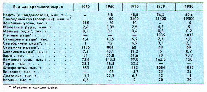
 Minerals. In Algeria, deposits of oil, natural gas, coal, uranium ores, iron, manganese, copper, lead, zinc, mercury, antimony, gold, tin, tungsten, etc. have been discovered and explored (Table 1).
Algeria ranks third in Africa in terms of oil reserves. On the territory of Algeria, 183 and are known, confined to the Algerian-Libyan; Most of the deposits are located in the northeast of the Sahara region. The largest oil field is localized in Cambrian-Ordovician sandstones. The fields of Zarzaitin, Hassi-Tuile, Hassi-el-Agreb, Tin-Foue, Gourd-el-Bagel, etc. have significant reserves. Algeria ranks first in Africa in terms of gas reserves. The largest gas field lies in Triassic sandstones; significant gas reserves have been explored in the Gurd-Hyc, Nezla, Oued-Numer and other fields.
Coal reserves are insignificant; its deposits (Kenadza, Abadla, Mezarif) are concentrated in the Upper Carboniferous sediments in the Beshar basin. The coals are fatty, caking, medium ash (8-20%), contain 20-35% volatile impurities and 2-3.5% sulfur.
Algeria ranks 4th in Africa in terms of uranium ore reserves. Hydrothermal vein deposits of uranium ores Timgauin, Tinef and Abankor have been explored in Ahaggar (proven reserves 12 thousand tons, U3O8 content 20%); in the south of the shield, uranium occurrences are known in Paleozoic sandstones (Tahaggart).
Algeria ranks second in Africa in terms of iron ore reserves. In Northern Algeria, metasomatic iron ore deposits have been explored in Aptian reef limestones (Jebel Ouenza, Bou Khadra), the total reserves of which are over 100 million tons, the Fe content is 40-56%. In the Tindouf syneclise, the largest Devonian sedimentary deposits of oolitic iron ores in Algeria were discovered - Gara-Dzhebilet (total reserves 2 billion tons, Fe content 50-57%) and Mesheri-Abdelaziz (2 billion tons, 50-55%). The reserves of manganese ores are insignificant; they are confined to the volcanic-hydrothermal deposit of Oued Guettara (total reserves 1.5 million tons, Fe content 40-50%) in the Bechar region.
Algeria ranks second in Africa in terms of lead and zinc ore reserves. In Northern Algeria, vein (telethermal) and lens-shaped vein (hydrothermal) deposits of polymetallic ores are developed. Stratiform deposits of lead and zinc ores are located in carbonate deposits of the Jurassic (El-Abed, Deglen), Cretaceous (Kerzet-Yousef, Meslulla, Jebel Ishmul), veins in sandy-clayey rocks of the Cretaceous (Gerruma, Sakamody) are associated with diapirs of Triassic evaporites. Volcanogenic and plutonogenic-hydrothermal copper-polymetallic deposits in Cretaceous-Neogene rocks are associated with Miocene volcanics (Bu Sufa, Oued el-Kebir) and granitoids (Bu Douka, Ashaysh, Ain Barbar, Kef um Tebul). Ore occurrences of cuprous sandstones are known in Cretaceous and Triassic deposits (Ain Sefra, in the western Saharan Atlas), Cambrian (Ben Tajik in Ugarta) and Vendian (Khanq in the south of Regibat).
Algeria ranks 1st in Africa in terms of mercury reserves (about 4% of global reserves). Deposits were discovered in the Azzab area among the Cretaceous-Paleogene terrigenous-clastic rocks and in Precambrian shales (Genisha deposits - total reserves in terms of metal 4.5 thousand tons, Hg content 1.16%; Mpa-Sma, respectively 7.7 thousand tons, 3.9%; Ismail - worked out). Algeria ranks 2nd in Africa in terms of ore reserves; they are concentrated in Northern Algeria at the Khammam-Nbails telethermal field. Algeria ranks first in Africa in terms of tungsten ore reserves. In Ahaggar, quartz-cassiterite-wolframite-greisen-vein bodies Nahda (Launi), Tin-Amzi, El-Kapycca, Bashir, Tiftazunin and others, associated with Taurirt granites, have been explored. In Northern Algeria, the Belelieta skarn-scheelite deposit is known.
The most significant vein gold deposits - Tiririn, Tirek, Amesmessa, Tin-Felki, etc. - were explored in the Precambrian crystalline rocks of Ahaggar; exploration and search for gold continues.
The Bou-Douau deposit has been discovered in Northern Algeria.
Algeria ranks 5th in Africa in terms of phosphorite reserves. In Northern Algeria, deposits of granular phosphorites are confined to clay-carbonate deposits of the Upper Cretaceous - Paleogene. The largest deposits are Dzhebelyonk, El-Quif, Mzaita (see Arabian-African phosphorite province).
In terms of reserves, Algeria ranks 2nd in Africa. In Northern Algeria, the Mizab vein deposits (total reserves 2.15 million tons, BaSO content 4 90%), Affensou, Bou Mani, Varsenis and Sidi Kamber have been identified; in the Bechar region - the Bou Kais, Abadla and other vein fields. Among other minerals, a large deposit of Beni Mansour (Northern Algeria) has been explored in Algeria, the total reserves of which are 6.1 million tons; deposits are known (reserves are small), cookery, etc.
History of the development of mineral resources. The oldest evidence of the use of stone for making tools was found in Ternifin and dates back to the Lower Paleolithic (about 700 thousand years ago). From the Neolithic era, the extraction of clays for the manufacture of ceramic utensils began (5-4th millennium BC), from the 2nd millennium BC. - stone for the construction of large funeral structures - dolmens. Information about the developed mining and metallurgical production in the Middle Ages is given in the works of Arab scientists and travelers al-Yakubi (9th century), al-Bakri (11th century), al-Qazwini (13th century), etc. The main mining centers were concentrated in the north - iron ore mines "Nemours" and "Beni-Saf" near the city of Arzev (Western Algeria), as well as near the cities. Setif, Annaba, Bejaia; copper ore in the Jebel Ketam mountains. In the department of Constantine (near Majana, Eastern Algeria), the development of deposits of silver, lead ores, and building stone (no later than the 16th century) is also mentioned. Mercury ore was mined near the city of Arzev. In the 10th century, salt mines were located on the Jebel el-Melkh hill ("Mountain of Salt").
After the colonization of Algeria (1830), intensive searches began in the country. Industrial exploitation of iron ore deposits (Ain Mokra, Beni Saf, Jebel Ouenza, Mokti el-Hadid) has been carried out since the 50-60s. 19th century, at the same time intensive development of deposits was carried out, and (Muzaya, Oued-Merja, Tizi-Ntaga), phosphorites (since 1893). In 1907, the main coal deposit in Algeria, Kenadza, was discovered, the maximum production of which was carried out during the Second World War 1939-45.
 Mining. General characteristics. The leading branch of the mining industry is oil and gas production (more than 90% of the value of all products of the mining industry); provides the majority of foreign exchange earnings. In 1981, oil and gas accounted for 96% of the value of the country's exports, which amounted to 62 billion Algerian dinars. In the mining industry, the public sector plays a leading role. In the oil and gas industry, a monopoly position is occupied by the state company "Société Nationale pour la Recherche, la Production, le Transport, la Transformation et la Commercialization des Hydrocarbures" ("SONATRACH"). The company has taken control of oil and gas reserves and production, all main oil and gas pipelines, gas liquefaction and oil refining plants. The total number of personnel employed in the oil and gas industry is about 36 thousand people (1980). The Algerian government is promoting the development of the oil and gas industry by merging with foreign capital (up to 49%) while retaining 51% of the shares with SONATRACH. The company carries out production, as well as oil and gas, in the Sahara together with the French companies "Total", "Compagnie Française de Pétrole", "Compagnie de Recherches et d'Activities Pétrolières", companies in the USA (Getty Oil Co.), Spain ("Hispanoil"), Germany ("Deminex"), Poland ("Copex") and Brazil ("Petrobras"). After the nationalization of mines and quarries (1966) in the mining industry of Algeria, the state company "SONAREM" fully controls the exploration, production, consumption and export of all solid minerals (total number of employees about 14 thousand people, 1980). The company includes 30 mines and quarries, conducts exploration in Northern Algeria and the Sahara. Algeria is one of the leading producers of mercury (Table 2).
The extraction of iron ores and non-ferrous metals is insignificant (See map.).
Oil industry. For the first time in the country, oil exploration began in the northern regions in 1875, and production on a small scale began in 1913. The discovery of large oil fields in the Sahara region in 1956 served as the basis for the rapid development of the oil industry (industrial production began in 1958). This was also facilitated by the commissioning in 1960 of Hassi Mesaoud - Bejaia and Ejele - Sehira (Tunisia) with a throughput capacity of 14 million tons per year each. The Algerian oil industry was partially nationalized in 1971. SONATRACH controls 77% of oil production (1981). In 1981, in terms of this indicator, Algeria ranked 14th among industrialized capitalist and developing countries and 3rd among African countries (after Libya and Nigeria).
The main production areas are the oil fields of Haud-Berkaoui, Hassi-Mesaoud, El-Hassi, Hassi-el-Aghreb, and Ghurd-el-Bagel. Products also come from the oil and gas fields of Hassi-Tuil, Gurd-Hyc, and Nezla. In 1981, the number of operating oil wells was 1050. The oil is light and low in sulfur. Algeria exports most of its raw materials (up to 70%) (mainly to Western European countries). The most important ports of shipment are Arzev and Skikda. Large oil pipelines: Assakai-faf - Sehira (Tunisia), Hassi-Mesaoud - Bejaia, Hassi-Mesaoud - Arzev, Mesdar - Skikda, etc. The total length of all oil pipelines is over 4.5 thousand km (1980).
The capacity of Algeria's oil refining industry is designed to meet the needs of the domestic market. In the early 80s. in Algeria there were 5 with a total annual production capacity of 21 million tons. The country took a course towards saving its own oil resources and their rational use (in 1979 the production volume decreased by 10%, in 1980 - by 15%); by 1990 it is also planned to partially replace oil exports with the export of petroleum products. Exploration work is intensifying. In 1980-1981, about 20 agreements were concluded with foreign companies (,). In 1980, 249 were drilled (76 produced oil, 96 produced gas).
Gas industry. Natural gas production in the country began in the 60s. 20th century and is growing at a high rate (in 1971-80 an average of 14% per year). In terms of commercial production in 1980, Algeria ranked 1st among developing countries. Algerian industry is characterized by an export orientation. About 30% of produced gas is exported. Over 1/3 of the produced gas is supplied to the external market. Importers - France, Spain, USA. The dynamic development of the industry is explained by the presence of large reserves of raw materials and the proximity of such a capacious gas market as Western Europe. Algeria's gas industry was nationalized in 1971. The overwhelming volume of gas production, transportation and sales falls on the SONATRACH company, which directs the bulk of its capital investments to the development of the gas industry. The largest field under development is Khassi-Rmel.
To the southeast of it there are several oil and gas fields, the most important of which are Alrar, Gurd-Hyc, Nezla, etc. To the southwest of Hassi-Rmel there is a group of smaller gas fields. The development of deposits in these areas is expected to begin after the construction of gas pipelines to the Khassi-Rmel field.
Most of the gas comes from oil fields. In 1978, the share of associated gas in the total volume of gross production (32.5 billion m3) was 57%. Due to the lack of necessary transport systems, this type of raw material is burned in flares (38% of total production in 1978) or injected into oil reservoirs (20%). Algeria ranks 3rd in the world in exports of liquefied gas. There are four enterprises in the country: three in Arzev with a total annual capacity of 22 billion m3 and one in Skikda with a capacity of 9 billion m3.
The extracted gas is pumped through the main gas pipelines Hassi-Rmel - Arzev (two lines with a total capacity of 3.8 billion m 3 per year) and Hassi-Rmel - Skikda (13.5 billion m 3 per year) to sea ports for further supplies to the foreign market. There is also an extensive gas distribution network for supplying gas to consumption centers. The total length of the gas pipeline network in Algeria is about 4 thousand km. In 1981, the construction of the Trans-Mediterranean gas pipeline Algeria - Italy (2500 km) was completed, which runs through the territory of Tunisia, through the Strait of Sicily, Sicily, the Strait of Messina to the southern regions of Italy. The throughput capacity of the gas pipeline is 12 billion m 3 per year; it is possible to increase it (due to the construction of additional compressor stations) to 18 billion m 3. A project is being developed for the construction of the Algeria-Spain Trans-Mediterranean gas pipeline through the Strait of Gibraltar with a throughput capacity of up to 40 billion m3 per year.
Mining and chemical industry. The basis of the raw material base of the mining and chemical industry of Algeria is its reserves of phosphorites. The development of the extraction of this mineral in Algeria was constrained by the fact that in the region its quality is much inferior to Moroccan and Tunisian phosphorites. In terms of phosphorite production, Algeria ranks 10th among industrialized capitalist and developing countries (1980), providing about 1.5% of their total production. Mining is concentrated mainly at the Jebel Onk quarry with a production capacity of 3.6 million tons of ore per year. Reserves within the quarry field exceed 200 million tons. The main mining equipment is draglines. The mined ore undergoes primary processing. Due to the content of organic impurities and carbonates in it, it is enriched by calcination in a fluidized bed at a temperature of 900°C. The bulk of phosphorites mined in Algeria is exported, mainly to Western European countries. It is planned to significantly expand the production of phosphate fertilizers from our own raw materials. In this regard, Algeria signed contracts with the Polymex Cekop company (Poland) and the Marubeni Hitachi consortium (Japan) for the construction of fertilizer plants in the cities. Annaba and Telessa. By 1990, the volume of production is expected to increase to 3.65 million tons.
Algeria has quite large resources of barium raw materials. At the same time, the volume of mineral production in the country is small - about 1.5% of industrialized capitalist and developing countries. Some growth in production has been noted since the early 70s. and is associated mainly with the needs of the oil and gas industries. The development of barite deposits (veined ones predominate) is mainly concentrated in the region. Ain Mimoun, Sidi Kamber, Mokla. It is carried out both open and underground. Flotation is used to enrich ore. It is planned to increase the annual production of barite to 150 thousand tons. Pyrite deposits are being developed in small quantities in the country (no more than 20 thousand tons per year, in terms of sulfur).
Iron ore mining. In Algeria, iron ore mining is carried out by open and underground methods in the deposits of Jebel Ouenza, Bou Khadra, Hanget, and Beni Saf. The largest deposit and promising production area is Gara Dzhebilet in the southwest of the country. Mining is carried out by open-pit mining by the state company "Société Nationale de Recherches et d" Exploitations Minières" ("SONAREM") with the involvement of Moroccan capital and amounts to 4.2 million tons of ore per year (1979). The development system is transport. Iron ore serves as a raw material for metallurgical plant El-Hajjar, near the port of Annaba. For the export of mined ore, it is planned to build a 1100 km long railway to the Algerian coast of the Mediterranean Sea, where it is planned to create (in the early 90s) a large metallurgical plant (in La Macra, between Arzew and Mostaganem) It is planned to expand iron ore production to 13.1 million tons by 1990.
Mercury mining. Algeria is one of the leading producers of mercury. It accounts for about 1/4 of the total production of mercury ores in industrialized capitalist and developing countries. Mining has been carried out by the Mercure d'Ismail company in the open pit in the Azzab area since 1971. There is also a metallurgical plant for processing ores here. Geological exploration for mercury ores is carried out by SONAREM.
Other minerals. Lead, zinc, copper, silver ores, marble, rock salt and other minerals are mined in small quantities in Algeria. Copper concentrates are obtained from raw materials from the Ain Barbar deposit; After the commissioning of new mines (Bu Douka, Kef um Teboul, Bu Sufa), copper ore production can be tripled. The production of zinc ores by 1985 should increase to 38 thousand tons (in terms of metal), by 1990 to 45 thousand tons, the production of lead ores to 19.2 thousand and 27.2 thousand tons, respectively. In Ahaggar it is planned (1985) to develop tungsten deposits Nahda (Launi), gold (Tiririn, Tirek, etc.) and uranium (Timgauin, Abancor).
Mining and Geological Service. Personnel training. Seal. Mining and geological work in Algeria is headed by the Directorate of Mines and Geology within the Ministry of Heavy Industry, which includes the following departments: mining, prospecting, laboratory research and services. The latter supervises the work on problematic geological mapping, publishes geological maps and collections of works. Geological research is carried out at the Institute of Petroleum (centers in Algiers, Hassi-Mesaoud and Oran).
Personnel training is carried out at the University (Algeria), the African Center for Hydrocarbons and Textile Industry (Boumerdes), the Polytechnic School (El Harrache) and the Technical Mining School (Miliana).
The main publications on geology are published in the journals: "Bulletin du Service de la Carte Géologique de l'Algérie" (since 1902); "Bulletin économique et juridique Alger" (since 1937).


